2010/08/05

Rivière-du-Loup

Today, we would be leaving Forillon National Park and return to Rivière-du-Loup, so at 9:00pm, after packing up, our long car ride began.

 
An authentic photo of a black bear
At 10:00pm, my dad had decided to visit a trail in Forillon on our way out. There was nothing special about this trail and I was complaining about it being a waste of time before I spotted a black bear a hundred metres away! I immediately bolted off the van with my camera and took a photo as fast as I could before the black bear disappeared into the forest. Because I was at least a hundred metres away (Black Bear country rules state that tourists must stay at least a hundred metres away), my photo seemed very vague and blurry. Without thinking, I ran forward with my dad hot on my heels and right to the spot in which the bear had disappeared into the forest. I searched the dense vegetation for the black bear, but to no avail. Then, my eyes locked onto two orange beads staring back at me about two metres in front of me. My brain froze for a split-second to take the whole situation in and in the next second, I realized that the black bear was standing less than an arm’s length from my face (no exaggeration at all)! I realized that I was staring the black bear down (something you are prohibited from doing) and my mind suddenly went blank. All of a sudden, realizing the danger, the black bear growled and appeared to leap forward. I backed away as fast as I could and avoided possible death (if the bear had lunged and attacked me, I would have been mauled). I thought that the bear was going to chase us, but thankfully, it wasn’t a mother. As I walked back to my van, I realized that I might have had the closest encounter with a black bear in the history of Forillon (face to face) and that I was extremely lucky that the bear did not attack me. According to the Black Bear Safety section of my Forillon National Park map, never look a black bear in the eye, never startle a black bear, always stay one hundred metres away from a black bear, and I had disobeyed ALL THREE RULES!!!

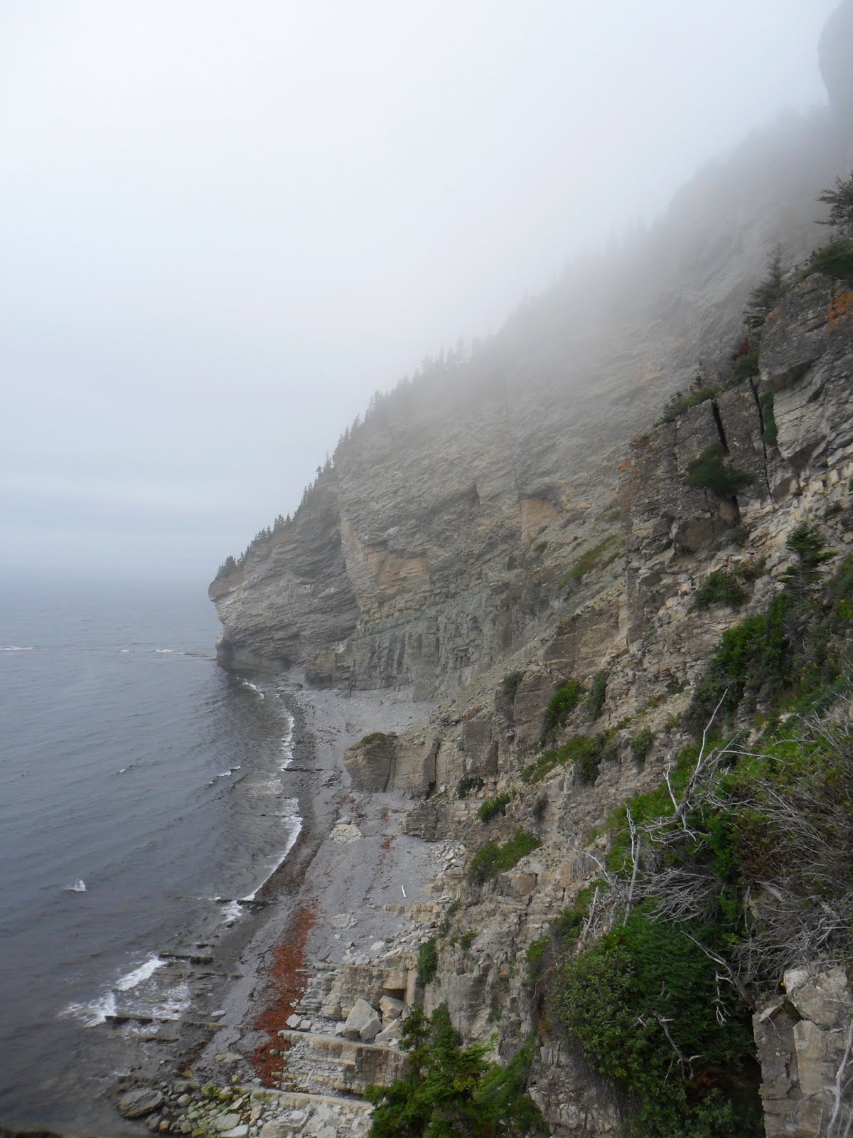
   My excitement slowly died down over the few hours after my black bear encounter. As we drove back to Rivière-du-Loup, I noticed that the landscape was similar to that of Cape Breton Highlands. Then, I realized that the Appalachian Mountain range covered both Cape Breton Highlands and Gaspe Peninsula, explaining the similarities in the scenery.

   At 5:00pm, we returned to our starting point; Rivière-du-Loup. This time, we settled into the campground that was adjacent to the motel that we stayed in on the first day. After unpacking, I took a long and well-needed shower in the clean washroom (this campground was also private, but the showers were free)! At 7:30pm, our campsite was attacked by the most vicious and horrible mosquitoes I had ever encountered. There were literally mosquitoes flying everywhere! Then, I remembered that there was a petting zoo in the campground, which explains the infestation of mosquitoes at our campsite. After a hard-fought battle against the mosquitoes, I entered the tent at 8:30 to attend to my wounds. My dad told me that I should go to sleep because tomorrow, we would be heading home. I was too tired to disobey his commands and thus at 9:00pm, I fell asleep for the last time on this trip...

   As I was drifting off into my dream, I recounted all the memories and fun I had over the past two weeks. From the fun at Hopewell Rocks and the bear and moose encounters, I thought that this was the best trip I had ever experienced in my entire life, but then I remembered what was in store for me next year; my parents would be taking me on a journey to Banff!!!

2010/08/04

Forillon National Park, Quebec


The incredible fog
  This morning (), we drove into Forillon National Park and decided to take a hike on the Les Graves Trail. Les Graves is an eight kilometre long trail that winds its way to the very edge of the Gaspé Peninsula (Cape Gaspé).
Visible layers of Sedimentary Rock

At the beginning of the trail, I noticed visible layers of sedimentary rock found on the beach shore. Over a long period of time, sediments were deposited and slowly compressed until the bottom layer became solid rock.

We walked for the whole morning in silence, as fog dominated the sky (result of Labrador and Gulfstream ocean currents). Along the way, I spotted numerous remains of black bears and remembered that Forillon National Park is known for its large black bear population.


 At , we reached the end of the trail and the end of Gaspé Peninsula (end of the Appalachian Mountain range as well). I took some photos, but the fog ruined the scenery.
My brother looking up
 at the 400m ascent

We returned to the parking lot and without catching a break (except for a twenty minute lunch), we immediately started another trail! This trail (Mont Saint-Alban) is 3.2 kilometres long (round trip), but at the start of the trail, there is a vertical ascent of 400m while the trail only progresses 200m! After climbing to the top of this stretch of the trail, I was extremely exhausted and almost fainted. And to only think that we only completed 200m of the trail!

The grand view from the
summit of Mount Saint-Alban


You’d think the remaining 1.4 kilometres would be on flat land, but sadly, the trail continued to ascend (it never descended). I figured that Mount Saint-Alban must have been part of the Appalachian Mountain range. At , we reached the summit (what a relief!) and took lots of photos from here. We were approximately a kilometre above sea level, but the fog had failed to clear and the result was an obscured view of the land below us. After catching our breath, we descended back down (much easier) and returned to the parking lot. 
The tall coniferous trees
at Cape Gaspe


With nothing else to do for the rest of the day (not that anyone in my family had the strength for another trail), my dad decided to return to our campsite extra early since today was the most physically exhausting of the entire trip. I had a nice dinner and fell asleep in my sleeping bag at . 


2010/08/03

Forillon National Park, Quebec

 As usual, I woke up at , had breakfast, and packed our tents up (what’s new?). We left our campsite at and headed towards Parc-ile Bonaventure, which means island of good adventure in English. I used our GPS to locate Parc-ile Bonaventure, and after thirty minutes of following its instructions, we found ourselves lost in the middle of nowhere. My dad started blaming me and the GPS and after forty more minutes of driving around, we finally reached Percé. 
   
My brother staring at
Percé rock
At , as we approached the town of Percé, I noticed a huge rock formation in the middle of the Gulf of St. Lawrence. My dad quickly purchased six tickets (total of $150 dollars) for a boat tour around the rock formation and access to Bonaventure Island.

Approaching the Percé Rock  
We hopped aboard the Felix Leclerc at and began our tour of the Percé rock. The tour guide talked in both French and English (thankfully!) and I was able to understand and learn some important facts about the Percé rock. Translated into English, Rocher Percé means “pierced rock”. The rock earned its nickname because of a small arching hole found near the base of the rock. The small arching hole was a unique result of millions of years of erosion. Thousands of fossils of early marine life, such as trilobites, brachiopods, etc, can be found within the layers of limestone that make up the rock formation. 

The arch in the limestone

Seals basking in the sun
As we neared the natural wonder, I spotted numerous seals (possibly harbour seals) basking in the sun and thousands of birds perched in the wedges and on the cliffs of the rock. The guide explained that hundreds of thousands of birds make their homes on Percé rock and Bonaventure Island.   

After circling Percé rock, the boat arrived at Bonaventure Island at , where everyone disembarked. The island’s main feature was the breeding ground of hundreds of thousands of Northern Gannets, along with three different trails to reach the breeding grounds. Before we started, we had lunch in the café, where lobster sandwiches were sold for ten dollars each!  

Bonaventure Island's breeding ground for
thousands of Northern Gannets
After thirty minutes of hiking, we reached the Northern Gannet breeding ground (although I could have smelled and heard it kilometres away). There was a rancid stench that filled the air (possibly from the excess of bird poop and lack of hygiene). Flies buzzed everywhere, yet I was too distracted by the vast number of gannets occupying the area. The breeding ground was approximately two hundred metres long and fifty metres wide, with a gannet occupying every square metre. Everywhere I looked, I saw gannets; gannets fighting; gannets mating; gannets feeding; gannets flying; the list goes forever! I took a billion photos and caught two gannets mating. Another cute gannet was pulling grass from the ground and waddling with the grass in its beak to its nest. Then, I noticed the baby gannets; small, grey bundles of feathers. I saw lots of babies, but sadly, most of them were dead, so I didn’t bother taking photos of them.   

Soon, my family began to snap out of its awe and realize the rancid stench and countless black flies that flied around. After fifteen minutes at the breeding ground, we decided to leave and return to the dock. The boat came at and we hopped on and returned to Percé.

At , we left Percé and headed towards Forillon National Park, our next destination. By , we reached Forillon’s campground, but sadly, all the campsites were taken and there was no vacancy! We desperately turned around and headed back down Highway 132 until we came across a private campground. Here, we unpacked and set our tents up at . I wanted to take a shower, but since it was a private campground, one had to pay a buck per minute of hot water and thus I opted not to wash myself (a five dollar shower was pretty ridiculous).

After brushing my teeth, I headed back to our campsite. Since I was bored and tired, I decided to fall asleep earlier than usual so that I would be well-rested for tomorrow’s trails and thus I entered our tent at and fell asleep at .

2010/08/02

Percé, Quebec

  When I woke up this morning (), I was greeted by a rotting and pungent odour. I changed, washed myself, and had a breakfast of lobster tails (from the day before) and sardines. During breakfast, everyone in my family was complaining of the sharp smell and upon sniffing everyone, my brother determined the source of the odour; me. I smelled myself and discovered that the odour was coming from my jacket. I took my jacket off and immediately, the smell was gone. My mom went to clean my jacket, and discovered a couple of shells in them. Then I realized that the shells that I had picked up on the beach yesterday rotted in my pocket and released the nasty smell. After the confusion, we packed our tents and prepared to go canoeing!     
  
 
My brother and I happily canoeing
Prior to today, I had gone canoeing three times in my life. A year ago, I went on a three day canoe trip in the Laurentian forest with my dad and other adventurers. Today, however, my dad and I would be canoeing along with the rest of my family. We rented two canoes and began to paddle along the Kouchibouguac River. Along the shores, I spotted a cormorant and took a picture of it (below). We paddled for an hour, then turned our canoes around and paddled back to the dock. I saw a great blue heron, but it was wading too far away for me to take a photo. 

  
A cormorant
At , we left Kouchibouguac and continued to drive north. We left New Brunswick and entered the Gaspé Peninsula of Quebec (2:00pm Atlantic Time). I thought that we would head west and back to Toronto, but my dad turned the car east and headed towards Percé.

We drove for four hours, passing through small Quebec towns, before finally coming to a stop at a private campground near Percé. I used my French skills to communicate with the French owner and at , we settled into our campsite.

Because we crossed back to the Eastern Time Zone, I had to set my watch back an hour, which meant one less hour of sunshine. After dinner (congee and various meat and vegetables), the sky quickly darkened so we decided to start a campfire. My brother and I played around with the fire for thirty minutes (lighting twigs up) before fatigue kicked in. By , I entered our tent and decided to go to sleep.

2010/08/01

Kouchibouguac National Park, New Brunswick

   As usual, I woke up at 8:00am, helped pack our tents up, ate a breakfast consisting of sardines and bread, and hopped into the van for a long car ride to our next destination (I had grown accustomed to this routine). Today, we left Stanley Campground at and headed towards the Confederation Bridge.  

     At , we reached the Confederation Bridge. We paid the toll ($43.95) and began to drive over the world’s longest bridge crossing ice-covered waters (as stated on my PEI map). Ten minutes later, we reached New Brunswick and stopped at the Confederation Bridge tourist centre. Here, I took lots of photos and for once, I was in one of them! 
 
 
The Confederation Bridge
After the thirty minute break, we began to head north and stopped at Shediac, New Brunswick at . We visited Shediac’s main attraction; a giant lobster! While I took photos of my brother climbing on the lobster, my mom went and bought lunch; two giant lobsters for fifteen dollars! For the second day in a row, we had lobsters for lunch (we paid two hundred dollars less compared to yesterday at the Fisherman’s Wharf). 
    
My brother fooling around
on the giant lobster

  At , we left Shediac and drove towards our next destination; Kouchibouguac National Park. At first, I couldn’t even pronounce the park’s long name. After arriving at Kouchibouguac (), we visited the visitor’s centre and my mom made me read all the information they provided. I learnt that the name Kouchibouguac, of Mi’kmaq origin, means “river of the long tides”, but apart from that, I didn’t gain any useful knowledge. We then proceeded to register for our campsites but were alerted by the campground officials that there were no more campsites available. My dad became enraged before the officials told my dad that they were joking around. 
 

A dead jellyfish found
on the shore
After settling into our campsites, we visited the beach. No one in my family felt like hitting the saltwater Kouchibouguac Bay so instead, we walked along the shores of the marsh beside the beach. At that time, the marsh was experiencing the low-tide, because scattered along the shores of the marsh were hundreds and hundreds of dead jellyfish! I had only encountered a single jellyfish in the wild before (in Cuba, a dead Man-o-war jellyfish) and today, I saw hundreds of pink and orange jellyfish lying on the shores. I figured that when the tide receded, the jellyfish were stranded and died from lack of moisture. Anyways, I found it interesting that jellyfish resided in New Brunswick! 
  
Another victim/s
(my brother and the starfish)
 of the low-tide
  My family then turned around and headed back towards the parking lot. Along the way, I found a couple of shells and slid them into my pocket.

At , my dad announced that for tonight, we would be having a barbeque. This brightened up my day, as a barbeque meant sausages, lamb chops, and wondrous chicken wings! After dinner, we played some card games and called it a day at . According to my dad, we will be leaving Kouchibouguac tomorrow and that we needed a lot of rest tonight, so naturally, I went to sleep at .

2010/07/31

Stanley Campground, Prince Edward Island

I awoke at and began to make breakfast by myself (that is, taking our food out of the freezer). At , we left for Greenwich National Park after having sausages for breakfast.

As we drove along Highway 2, I noticed that wherever I looked, I would find farms and/or orchards and vineyards of some sort. The gently rolling landscape (as opposed to the highlands of Cape Breton) and the lack of urban influence (noise, pollution, bright lights, etc) convinced me that in the future when I retired, I would move to PEI.

At , we entered the National Park, paid the admission fee of five dollars, and began to walk along the Sand-Dunes Trail (4.5 kilometres long with return trip). According to my map, we would experience a vast change in landscape as the trail progressed. 
    
Rapid change in landscape,
 from marshes to grassland,
to sand dunes

The meadows at the
 beginning of the trail
The beginning of the trail was surrounded by meadows. Soon afterwards, the meadows were replaced by a giant forest, in which squirrels and fox footprints were sighted. As quickly as it appeared, the forest disappeared and a marsh emerged. While walking along the boardwalk, I spotted a beaver swimming in the pond. A hundred metres later, the marsh was replaced by sand dunes. The series of landscape and wildlife changes fascinated me, as the transition from meadows to sand dunes was truly wondrous. I explored the sand dunes and took plenty of photos of my family. After playing around in the very soft smooth beach sand, we turned around and headed back towards the parking lot.
My little brother and the sand dunes
   At , we returned to the parking lot and began to drive towards Rustico, where we would have our lobster feast. The restaurant’s prices were ridiculous and made The Keg seem like a very ordinary restaurant. The fancy restaurant’s main feature was a 60 foot salad bar (all-you-can-eat) with fresh mussels that tasted better than anything I had ever tasted in my life (no sarcasm in the italics and bolds, just emphasis). Our main course was two large lobsters and a plate of seafood including scallops, clams, and shrimp. The food was delicious, but sadly, extremely expensive at the same time. Our bill was an incredulous $256 dollars and prompted my dad to say: "All the money that we had saved by camping instead of living in motels was spent on this extravagant meal."

At , we left the restaurant and headed towards the Ann of Green Gables House. The admission prices were pretty ridiculous ($30 bucks a family which was equivalent to the admission prices of Hopewell Rocks) and my mom (being smart), decided to send me in by myself (I had a Grade 8 Parks-Pass that enabled me to get into any national park for free) and decide whether or not it would be worth paying to enter. The park itself was not spectacular and I immediately decided that it was a rip-off. I snapped photos of everything I saw (including the information boards) and quickly left.

After leaving the Ann of Green Gables House, we began to drive towards Tea Hill. On the way, we passed downtown Charlottetown, which was not much different from downtown New York City (minus the skyscrapers and office buildings).  

 
Wading and searching for
hermit crabs in the low-tide
After reaching Tea Hill at 4:30pm, I noticed that the tide of Hillsborough Bay had receded so much that the water only went up to our ankles (one could walk for a couple of kilometres and the water level would still not rise)! For the next couple of hours, my family scoured the bottom of the bay for hermit crabs and other small animals. With our pails, my brother and I collected dozens and dozens of hermit crabs and water snails with the intent on releasing them after the bucket became full. My brother even found a couple of large crabs (like the ones you buy in Chinese supermarkets) hiding underneath clumps of seaweed. Soon afterwards, we were joined by seabirds (seagulls and a great blue heron) looking for easy prey (because of the low-tide, the hermit crabs had no place to hide). Upon seeing the heron, I snapped twenty photos of the great blue heron, but sadly, I could not get close enough without scaring it to take a satisfying photo.  

  
A great blue heron searching for
easy prey in the low-tide
As I was walking around, I felt an irritating feeling on my left foot. Upon looking down, I saw a transparent yellow and red leech on my foot that immediately sent shivers and goose bumps through my skin. I kicked my foot around and made sure that the leech did not burrow its way into my skin. I inspected my foot and saw that there were no bite marks or blood.   
 
  
My little brother's excitement
  As the sun began to set (), my dad noticed that in the sand, small bubbles of air would rise up to the surface. He used our shovels and upon digging up the sand, he found live clams with meat inside them. For the next twenty minutes, we began to terrorize the animals living underneath the floor of the bay in search for clams. Sadly, most of the clams that we found were dead because their shells were opened and they emitted an atrocious smell. At , I attempted to remove all the footprints that my family had left by filling all the holes that my family created and releasing all the hermit crabs that my brother and I collected. We washed ourselves and began to head back to our campsite.  

Counting all the hermit crabs that we caught

Upon returning to our campsite at , I took a long bath (and washed my left foot with extra care). We had dinner at and after recharging my camera’s battery, I entered our tent at . By that time, I dropped into my sleeping bag and tried to fall asleep as quickly as possible so that I would be well-rested for tomorrow's fun...


2010/07/30

Stanley Campground, Prince Edward Island

   Yesterday, my dad told me that we would be leaving Cape Breton today and head towards Prince Edward Island. I was excited and disappointed at the same time, since Cape Breton was truly magnificent and I enjoyed every single minute of it (except for the time we spent on the Branch Pond Trail).

By , we had left Ingonish. Cabot Trail continued to climb the mountainous and rugged highlands and we were forced to follow at a slow pace of 20kms/hr (that’s how steep Cabot Trail had become!). Naturally, after reaching the peak of the highlands, Cabot Trail began to descend back towards the ground. When we reached the bottom, we were greeted by a 180° turn with a maximum speed limit of 10kms/hr!

By , we exited Cabot Trail and Cape Breton Highlands National Park (goodbye!). We drove for five hours before arriving at Pictou, Nova Scotia at . Along the way, our car was almost crushed by a truck when my dad decided to pass a slow vehicle in front of us on Highway 106 (my family almost had a heart attack)!  We reached Pictou ten minutes late and missed the 3:15pm PEI ferry, so for the next twenty minutes, my family played cards inside our van.
  
Vehicles driving into the PEI Ferry
  At , the ferry arrived! After five more minutes of waiting, vehicles were allowed to drive onto the ferry. The ferry was large enough for over a hundred vehicles to park inside it (on two separate floors too!). Inside the ferry, vehicles were parked in single-file lines; one after another and as you can imagine, the parking lot was crowded.
  
With forty minutes to kill, we exited the parking lot and climbed up to the deck to enjoy the fresh air (and view). As we were crossing the Northhumberland Strait, I sighted a porpoise in the distance, but sadly, I was too far away to take a good photo.

After buying six ice cream cones (one for each member of my family), the ship’s captain announced that we would be arriving at PEI in fifteen minutes and that passengers should return to their vehicles. We hastily finished our ice cream cones and climbed back down into the parking lot ruled by utter chaos and pandemonium. People were scrambling all over the place looking for their vehicles/family members. Luckily, we reached our van with relative ease.

"Welcome to Prince Edward Island!"
After docking (), the ferry’s gates opened, and luckily, our line was allowed to drive off the ferry first! We sped towards Highway 1 and were welcomed by a large sign (to the left). After driving on Highway 1 for an hour (with farms and orchards on both sides of the Highway), we reached Charlottetown, but sadly, we did not pass through the province’s capital. Instead, we switched onto Highway 2 and drove for another hour before we reached the Stanley campground.
  
After unpacking with great difficulties (the campsite was small and on the side of a hill) we were attacked by hungry mosquitoes. Most of our anti-mosquito equipment saw plenty of action in the twenty minutes it took for us to set our tents up and by , the mosquitoes had left! We had a quick dinner (instant noodles) and by 8:30, I was ready to enter the tent, however, my mom made me wash the dishes for the first time this trip! After an hour of dish washing, I entered our tent and fell asleep at 9:30pm...

2010/07/29

Cape Breton Highlands National Park, Nova Scotia

I woke up at 9:00am and discovered that my family had already finished eating breakfast (sardines, cold milk, and bread) and was impatiently waiting for me to do the same. When I stepped out of the tent, I found that the sky was filled with ominous-looking clouds, which threatened our streak of days without rain this trip.

At , we began to drive towards Meat Cove, the northern-most point of Cape Breton Island. After only driving for thirty minutes, rain began to fall. By the time we reached Meat Cove, the combination of rain and fog (the collisions of the Gulfstream and Labrador ocean currents) forced my family to turn the vehicle around and head back to Cabot Trail (what a waste of thirty minutes)! With a rainy afternoon to kill, I decided to take our family on a hike. Sadly, I chose the Branch Pond Trail (8.1 kilometres long), which cuts through the most wilderness area of the Highlands and climbs up the Highlands' interior plateau.
 

Grouse camouflaged
in the dense vegetation
We arrived at the trail's parking lot at 1:00pm and for a full hour, my family hiked up the trail and saw no signs of life (human or animal). I was particularly frightened by the fact that numerous black bears inhabited this area and felt that my family would be defenseless against possible attacks. Oddly enough, the only animal we encountered throughout the whole trail was a grouse (to the left)!


A spectacular view from the top of the
Branch Pond Trail
After thirty more minutes of hiking, we reached the lookout. I was expecting something Skyline-esque but sadly, this was not the Skyline Trail. Instead of the most spectacular views in the Atlantic Maritime, our ninety-minute hike was rewarded by some cheap and unspectacular view of forests, even higher highlands, lakes, and bays in the distance (as shown in the photo to the right). My family was exhausted and ticked off and began to descend back towards the parking lot. My dad and I decided to continue hiking (the trail continued to wind itself up past the lookout) and found ourselves following a trail that was as wild, rugged, and remote as an uninhabited island in the middle of the Pacific Ocean (yikes).

Along the trail, I discovered several moose footprints, several bear footprints, and several piles of dung of both moose and black bears. Coupled with the haunting scenery (this was no ordinary trek through the woods in Toronto), I wanted to turn back, but my dad made me press on. Soon, we encountered another hiker! He told us that the trail would get even more rugged up ahead, where thorns and prickly plants would cover the trail (showing how remote and wild this trail had become). My dad remained optimistic, even though a professional hiker (hiking stick, hiking backpack) had told us (sandals, walking sticks, no backpacks) that he had given up on the trail. Two minutes later, we met a hiking couple and engaged in a friendly conversation. At this point, I believed that should we encounter a black bear (who probably never met a human in its life because of the remoteness of the trail), the black bear would attack mercilessly and our names would appear as the top headline of tomorrow's newspaper (two hikers found mauled on the Branch Pond Trail). My dad was equally as scared as I was at that time and thus we decided to turn around and run back!

At 4:00pm, we returned to the parking lot and hastily drove away. We reached Ingonish Beach at 5:00pm and quickly found a campsite. Before we could unpack, rain began to fall from the sky. My family was drenched with rain after setting the two tents up. Wet, dirty, and tired, I decided to take a shower before it got dark. 


Franey Trail's Lookout
The rain never let up (frontal rainfall), but luckily, there was a picnic-shelter area and my parents decided to prepare our supper there. In the meantime, I discovered that had we taken the Franey Trail, we would have been rewarded with this view (briefly compare with the spectacular view from the Branch Pond Trail)!

After supper (comprised of fish balls, noodles, and veggies), my brother and I jumped into our van and proceeded to watch Kung-Fu Panda (on our portable DVD player) twice! I don't think that I have ever been that bored on this trip (except for maybe the first day).

At 9:00pm, my brother and I left the van, were greeted by a hoard of mosquitoes and pounding rain, and ran as fast as a hiker being chased by a black bear to our tent (which was only five metres away)! After settling down and worming myself into my sleeping bag, I heard an annoying buzzing sound (similar to the melody in Flight of the Bumblebee) and promptly turned my flashlight on in search for the villainous mosquito that had invaded our tent. After five minutes of searching, I finally spotted the bad-boy and squashed it with a tissue paper. By that time (9:30pm), I crawled back into my sleeping bag and immediately fell asleep.

2010/07/28

Cape Breton Highlands National Park, Nova Scotia

When I woke up this morning (8:00am), I felt extremely excited. Today, we would spend our first full day in Cape Breton Highlands National Park! We quickly packed our belongings and headed off towards the Skyline Trail.

  At , we arrived at the Skyline Trail. According to my mom, the trail is the main attraction in the national park. Looking in my park map, Skyline, 9.2 kilometres in length, offers hikers the most spectacular views in the Atlantic Maritime. In addition, moose, deer, and bear sightings are very common on the trail, so for the whole hike, I had high hopes in encountering a moose or two. 
  
Haunting trees that looked
like they were dead.
  At first, short grasses and dead trees surrounded the trail and I assumed that the soil was very poor. For a second, I felt scared by the possibility of turning a bend and surprising a black bear (with cubs!) that will fight for its life! Coupled with the eerie and uncomfortable silence, I opted to slow my pace down and walk with my family (instead of leading out in front).  

   Soon, the landscape changed, with coniferous and deciduous trees (alive with leaves/needles, not dead like before) popping out and looming over the trail (creating shadows). Five more minutes of hiking and the scenery changed again. As quickly as they appeared, the trees were replaced by short grasses (similar to those seen earlier). Fences were obstructed on the border of the transition from forests to grasses. A sign informed us that the fences kept the moose in the forest from overgrazing the low-shrub vegetation.   

Cabot Trail from
Skyline's lookout
Five minutes later, we reached the lookout point. Here, we were offered the best view of the Highlands and Gulf of St. Lawrence (just like the map had guaranteed). Here, I saw a bald eagle, but it was flying too far away for me to take a picture. Instead, I took multiple (around twenty) photos of the scenery, but sadly, I was not in any of them! As you can see, Cabot Trail twists and winds its way up and around the Highlands in the background of these three photos. 


Cabot Trail and Gulf of St. Lawrence
from the lookout
Grandfather posing


Female moose (called cows)
As we pressed on, I desperately scanned both sides of the trail for any signs of a bear  or moose. Suddenly, a dark cow-shaped figure resting in the shadows of the forest caught my eye.  Upon  scrutinizing the figure, I realized that right in front of my eyes was a female moose the size of a cow! I immediately ran back and told my chatty parents to zip it. I pointed out the moose and snapped a dozen photos (without flash of course) but sadly, I was too far away to get a quality shot. Sneakily (and with as little noise as possible) I wandered off the trail and approached the moose. Standing as close as I dared (close enough to snag a perfect picture, but far enough so that in case the moose felt threatened, I could retreat to safety), I took one photo (somehow with flash)! The moose grunted, and for a split second, I swore that it was going to charge! I took it as a sign that I was disturbing it and thus I ran back and onto the trail. By this time, a large hoard of hikers (who had caught up) were pointing and gasping at the moose, so my family decided to move on.
 
Male Moose (bull) partially
obscured by dense vegetation
After only travelling two hundred metres, I spotted another moose! Two moose in two hundred metres! Today was my lucky day! This one was a bull and had giant antlers sprouting from the top of his head. Unfortunately, I could not get a good position to take a picture because the moose was surrounded by thick vegetation. I took a few meaningless photos and left.
  
Young moose feeding
  After two moose sightings, I felt extremely satisfied and began to double my walking pace. I walked in silence for ten minutes and suddenly, I saw yet another moose! This time, it seemed as if the moose was a calf and I wondered if the two moose that I saw earlier were its parents. The moose was feeding and I could not get a proper photo from afar, so once again (driven by my excitement), I broke the park rules and scampered twenty metres into the forest and took a high-quality photo of the moose just as it was standing up!
  
As I returned to the trail and continued to hike back to the parking lot, I thought I saw a movement on the other side of the trail (possibly a black bear?). Then, I realized that my excitement was playing tricks on my mind.
  

Cabot Trail winding itself
up the Highlands
For the remainder of the trail, I did not spot a single animal (not even a bird), although the sight of three moose (and around fifty photos taken too!) delighted me and encouraged me to keep my eyes peeled for wildlife on other trails.

At 1:00pm, we returned to the parking lot and began to head northeast towards our next campground. We stopped at certain lookouts and I took those opportunities to take beautiful photos of the landscape (to the left).

We arrived at our next campsite (near Pleasant Bay) and decided to set our tents up early (4:00pm). After unpacking, I began to play cards with my parents once again, as we had five hours to kill. Once again, not a single mosquito invaded our campsite!

At 10:00pm, I decided to enter the tent and go to sleep. After encountering three moose and half a black bear today, I had no trouble falling asleep, as I began to dream about a potential black bear encounter tomorrow...