2010/07/31

Stanley Campground, Prince Edward Island

I awoke at and began to make breakfast by myself (that is, taking our food out of the freezer). At , we left for Greenwich National Park after having sausages for breakfast.

As we drove along Highway 2, I noticed that wherever I looked, I would find farms and/or orchards and vineyards of some sort. The gently rolling landscape (as opposed to the highlands of Cape Breton) and the lack of urban influence (noise, pollution, bright lights, etc) convinced me that in the future when I retired, I would move to PEI.

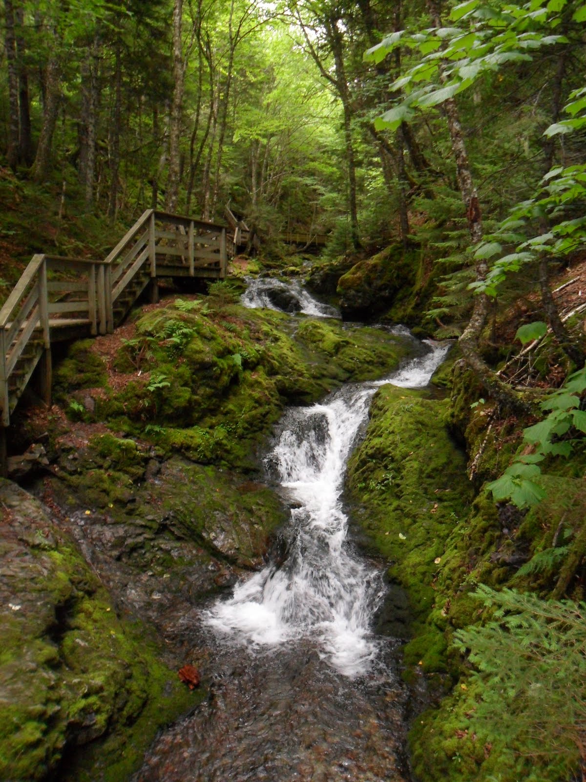
At , we entered the National Park, paid the admission fee of five dollars, and began to walk along the Sand-Dunes Trail (4.5 kilometres long with return trip). According to my map, we would experience a vast change in landscape as the trail progressed. 
    
Rapid change in landscape,
 from marshes to grassland,
to sand dunes

The meadows at the
 beginning of the trail
The beginning of the trail was surrounded by meadows. Soon afterwards, the meadows were replaced by a giant forest, in which squirrels and fox footprints were sighted. As quickly as it appeared, the forest disappeared and a marsh emerged. While walking along the boardwalk, I spotted a beaver swimming in the pond. A hundred metres later, the marsh was replaced by sand dunes. The series of landscape and wildlife changes fascinated me, as the transition from meadows to sand dunes was truly wondrous. I explored the sand dunes and took plenty of photos of my family. After playing around in the very soft smooth beach sand, we turned around and headed back towards the parking lot.
My little brother and the sand dunes
   At , we returned to the parking lot and began to drive towards Rustico, where we would have our lobster feast. The restaurant’s prices were ridiculous and made The Keg seem like a very ordinary restaurant. The fancy restaurant’s main feature was a 60 foot salad bar (all-you-can-eat) with fresh mussels that tasted better than anything I had ever tasted in my life (no sarcasm in the italics and bolds, just emphasis). Our main course was two large lobsters and a plate of seafood including scallops, clams, and shrimp. The food was delicious, but sadly, extremely expensive at the same time. Our bill was an incredulous $256 dollars and prompted my dad to say: "All the money that we had saved by camping instead of living in motels was spent on this extravagant meal."

At , we left the restaurant and headed towards the Ann of Green Gables House. The admission prices were pretty ridiculous ($30 bucks a family which was equivalent to the admission prices of Hopewell Rocks) and my mom (being smart), decided to send me in by myself (I had a Grade 8 Parks-Pass that enabled me to get into any national park for free) and decide whether or not it would be worth paying to enter. The park itself was not spectacular and I immediately decided that it was a rip-off. I snapped photos of everything I saw (including the information boards) and quickly left.

After leaving the Ann of Green Gables House, we began to drive towards Tea Hill. On the way, we passed downtown Charlottetown, which was not much different from downtown New York City (minus the skyscrapers and office buildings).  

 
Wading and searching for
hermit crabs in the low-tide
After reaching Tea Hill at 4:30pm, I noticed that the tide of Hillsborough Bay had receded so much that the water only went up to our ankles (one could walk for a couple of kilometres and the water level would still not rise)! For the next couple of hours, my family scoured the bottom of the bay for hermit crabs and other small animals. With our pails, my brother and I collected dozens and dozens of hermit crabs and water snails with the intent on releasing them after the bucket became full. My brother even found a couple of large crabs (like the ones you buy in Chinese supermarkets) hiding underneath clumps of seaweed. Soon afterwards, we were joined by seabirds (seagulls and a great blue heron) looking for easy prey (because of the low-tide, the hermit crabs had no place to hide). Upon seeing the heron, I snapped twenty photos of the great blue heron, but sadly, I could not get close enough without scaring it to take a satisfying photo.  

  
A great blue heron searching for
easy prey in the low-tide
As I was walking around, I felt an irritating feeling on my left foot. Upon looking down, I saw a transparent yellow and red leech on my foot that immediately sent shivers and goose bumps through my skin. I kicked my foot around and made sure that the leech did not burrow its way into my skin. I inspected my foot and saw that there were no bite marks or blood.   
 
  
My little brother's excitement
  As the sun began to set (), my dad noticed that in the sand, small bubbles of air would rise up to the surface. He used our shovels and upon digging up the sand, he found live clams with meat inside them. For the next twenty minutes, we began to terrorize the animals living underneath the floor of the bay in search for clams. Sadly, most of the clams that we found were dead because their shells were opened and they emitted an atrocious smell. At , I attempted to remove all the footprints that my family had left by filling all the holes that my family created and releasing all the hermit crabs that my brother and I collected. We washed ourselves and began to head back to our campsite.  

Counting all the hermit crabs that we caught

Upon returning to our campsite at , I took a long bath (and washed my left foot with extra care). We had dinner at and after recharging my camera’s battery, I entered our tent at . By that time, I dropped into my sleeping bag and tried to fall asleep as quickly as possible so that I would be well-rested for tomorrow's fun...


2010/07/30

Stanley Campground, Prince Edward Island

   Yesterday, my dad told me that we would be leaving Cape Breton today and head towards Prince Edward Island. I was excited and disappointed at the same time, since Cape Breton was truly magnificent and I enjoyed every single minute of it (except for the time we spent on the Branch Pond Trail).

By , we had left Ingonish. Cabot Trail continued to climb the mountainous and rugged highlands and we were forced to follow at a slow pace of 20kms/hr (that’s how steep Cabot Trail had become!). Naturally, after reaching the peak of the highlands, Cabot Trail began to descend back towards the ground. When we reached the bottom, we were greeted by a 180° turn with a maximum speed limit of 10kms/hr!

By , we exited Cabot Trail and Cape Breton Highlands National Park (goodbye!). We drove for five hours before arriving at Pictou, Nova Scotia at . Along the way, our car was almost crushed by a truck when my dad decided to pass a slow vehicle in front of us on Highway 106 (my family almost had a heart attack)!  We reached Pictou ten minutes late and missed the 3:15pm PEI ferry, so for the next twenty minutes, my family played cards inside our van.
  
Vehicles driving into the PEI Ferry
  At , the ferry arrived! After five more minutes of waiting, vehicles were allowed to drive onto the ferry. The ferry was large enough for over a hundred vehicles to park inside it (on two separate floors too!). Inside the ferry, vehicles were parked in single-file lines; one after another and as you can imagine, the parking lot was crowded.
  
With forty minutes to kill, we exited the parking lot and climbed up to the deck to enjoy the fresh air (and view). As we were crossing the Northhumberland Strait, I sighted a porpoise in the distance, but sadly, I was too far away to take a good photo.

After buying six ice cream cones (one for each member of my family), the ship’s captain announced that we would be arriving at PEI in fifteen minutes and that passengers should return to their vehicles. We hastily finished our ice cream cones and climbed back down into the parking lot ruled by utter chaos and pandemonium. People were scrambling all over the place looking for their vehicles/family members. Luckily, we reached our van with relative ease.

"Welcome to Prince Edward Island!"
After docking (), the ferry’s gates opened, and luckily, our line was allowed to drive off the ferry first! We sped towards Highway 1 and were welcomed by a large sign (to the left). After driving on Highway 1 for an hour (with farms and orchards on both sides of the Highway), we reached Charlottetown, but sadly, we did not pass through the province’s capital. Instead, we switched onto Highway 2 and drove for another hour before we reached the Stanley campground.
  
After unpacking with great difficulties (the campsite was small and on the side of a hill) we were attacked by hungry mosquitoes. Most of our anti-mosquito equipment saw plenty of action in the twenty minutes it took for us to set our tents up and by , the mosquitoes had left! We had a quick dinner (instant noodles) and by 8:30, I was ready to enter the tent, however, my mom made me wash the dishes for the first time this trip! After an hour of dish washing, I entered our tent and fell asleep at 9:30pm...

2010/07/29

Cape Breton Highlands National Park, Nova Scotia

I woke up at 9:00am and discovered that my family had already finished eating breakfast (sardines, cold milk, and bread) and was impatiently waiting for me to do the same. When I stepped out of the tent, I found that the sky was filled with ominous-looking clouds, which threatened our streak of days without rain this trip.

At , we began to drive towards Meat Cove, the northern-most point of Cape Breton Island. After only driving for thirty minutes, rain began to fall. By the time we reached Meat Cove, the combination of rain and fog (the collisions of the Gulfstream and Labrador ocean currents) forced my family to turn the vehicle around and head back to Cabot Trail (what a waste of thirty minutes)! With a rainy afternoon to kill, I decided to take our family on a hike. Sadly, I chose the Branch Pond Trail (8.1 kilometres long), which cuts through the most wilderness area of the Highlands and climbs up the Highlands' interior plateau.
 

Grouse camouflaged
in the dense vegetation
We arrived at the trail's parking lot at 1:00pm and for a full hour, my family hiked up the trail and saw no signs of life (human or animal). I was particularly frightened by the fact that numerous black bears inhabited this area and felt that my family would be defenseless against possible attacks. Oddly enough, the only animal we encountered throughout the whole trail was a grouse (to the left)!


A spectacular view from the top of the
Branch Pond Trail
After thirty more minutes of hiking, we reached the lookout. I was expecting something Skyline-esque but sadly, this was not the Skyline Trail. Instead of the most spectacular views in the Atlantic Maritime, our ninety-minute hike was rewarded by some cheap and unspectacular view of forests, even higher highlands, lakes, and bays in the distance (as shown in the photo to the right). My family was exhausted and ticked off and began to descend back towards the parking lot. My dad and I decided to continue hiking (the trail continued to wind itself up past the lookout) and found ourselves following a trail that was as wild, rugged, and remote as an uninhabited island in the middle of the Pacific Ocean (yikes).

Along the trail, I discovered several moose footprints, several bear footprints, and several piles of dung of both moose and black bears. Coupled with the haunting scenery (this was no ordinary trek through the woods in Toronto), I wanted to turn back, but my dad made me press on. Soon, we encountered another hiker! He told us that the trail would get even more rugged up ahead, where thorns and prickly plants would cover the trail (showing how remote and wild this trail had become). My dad remained optimistic, even though a professional hiker (hiking stick, hiking backpack) had told us (sandals, walking sticks, no backpacks) that he had given up on the trail. Two minutes later, we met a hiking couple and engaged in a friendly conversation. At this point, I believed that should we encounter a black bear (who probably never met a human in its life because of the remoteness of the trail), the black bear would attack mercilessly and our names would appear as the top headline of tomorrow's newspaper (two hikers found mauled on the Branch Pond Trail). My dad was equally as scared as I was at that time and thus we decided to turn around and run back!

At 4:00pm, we returned to the parking lot and hastily drove away. We reached Ingonish Beach at 5:00pm and quickly found a campsite. Before we could unpack, rain began to fall from the sky. My family was drenched with rain after setting the two tents up. Wet, dirty, and tired, I decided to take a shower before it got dark. 


Franey Trail's Lookout
The rain never let up (frontal rainfall), but luckily, there was a picnic-shelter area and my parents decided to prepare our supper there. In the meantime, I discovered that had we taken the Franey Trail, we would have been rewarded with this view (briefly compare with the spectacular view from the Branch Pond Trail)!

After supper (comprised of fish balls, noodles, and veggies), my brother and I jumped into our van and proceeded to watch Kung-Fu Panda (on our portable DVD player) twice! I don't think that I have ever been that bored on this trip (except for maybe the first day).

At 9:00pm, my brother and I left the van, were greeted by a hoard of mosquitoes and pounding rain, and ran as fast as a hiker being chased by a black bear to our tent (which was only five metres away)! After settling down and worming myself into my sleeping bag, I heard an annoying buzzing sound (similar to the melody in Flight of the Bumblebee) and promptly turned my flashlight on in search for the villainous mosquito that had invaded our tent. After five minutes of searching, I finally spotted the bad-boy and squashed it with a tissue paper. By that time (9:30pm), I crawled back into my sleeping bag and immediately fell asleep.

2010/07/28

Cape Breton Highlands National Park, Nova Scotia

When I woke up this morning (8:00am), I felt extremely excited. Today, we would spend our first full day in Cape Breton Highlands National Park! We quickly packed our belongings and headed off towards the Skyline Trail.

  At , we arrived at the Skyline Trail. According to my mom, the trail is the main attraction in the national park. Looking in my park map, Skyline, 9.2 kilometres in length, offers hikers the most spectacular views in the Atlantic Maritime. In addition, moose, deer, and bear sightings are very common on the trail, so for the whole hike, I had high hopes in encountering a moose or two. 
  
Haunting trees that looked
like they were dead.
  At first, short grasses and dead trees surrounded the trail and I assumed that the soil was very poor. For a second, I felt scared by the possibility of turning a bend and surprising a black bear (with cubs!) that will fight for its life! Coupled with the eerie and uncomfortable silence, I opted to slow my pace down and walk with my family (instead of leading out in front).  

   Soon, the landscape changed, with coniferous and deciduous trees (alive with leaves/needles, not dead like before) popping out and looming over the trail (creating shadows). Five more minutes of hiking and the scenery changed again. As quickly as they appeared, the trees were replaced by short grasses (similar to those seen earlier). Fences were obstructed on the border of the transition from forests to grasses. A sign informed us that the fences kept the moose in the forest from overgrazing the low-shrub vegetation.   

Cabot Trail from
Skyline's lookout
Five minutes later, we reached the lookout point. Here, we were offered the best view of the Highlands and Gulf of St. Lawrence (just like the map had guaranteed). Here, I saw a bald eagle, but it was flying too far away for me to take a picture. Instead, I took multiple (around twenty) photos of the scenery, but sadly, I was not in any of them! As you can see, Cabot Trail twists and winds its way up and around the Highlands in the background of these three photos. 


Cabot Trail and Gulf of St. Lawrence
from the lookout
Grandfather posing


Female moose (called cows)
As we pressed on, I desperately scanned both sides of the trail for any signs of a bear  or moose. Suddenly, a dark cow-shaped figure resting in the shadows of the forest caught my eye.  Upon  scrutinizing the figure, I realized that right in front of my eyes was a female moose the size of a cow! I immediately ran back and told my chatty parents to zip it. I pointed out the moose and snapped a dozen photos (without flash of course) but sadly, I was too far away to get a quality shot. Sneakily (and with as little noise as possible) I wandered off the trail and approached the moose. Standing as close as I dared (close enough to snag a perfect picture, but far enough so that in case the moose felt threatened, I could retreat to safety), I took one photo (somehow with flash)! The moose grunted, and for a split second, I swore that it was going to charge! I took it as a sign that I was disturbing it and thus I ran back and onto the trail. By this time, a large hoard of hikers (who had caught up) were pointing and gasping at the moose, so my family decided to move on.
 
Male Moose (bull) partially
obscured by dense vegetation
After only travelling two hundred metres, I spotted another moose! Two moose in two hundred metres! Today was my lucky day! This one was a bull and had giant antlers sprouting from the top of his head. Unfortunately, I could not get a good position to take a picture because the moose was surrounded by thick vegetation. I took a few meaningless photos and left.
  
Young moose feeding
  After two moose sightings, I felt extremely satisfied and began to double my walking pace. I walked in silence for ten minutes and suddenly, I saw yet another moose! This time, it seemed as if the moose was a calf and I wondered if the two moose that I saw earlier were its parents. The moose was feeding and I could not get a proper photo from afar, so once again (driven by my excitement), I broke the park rules and scampered twenty metres into the forest and took a high-quality photo of the moose just as it was standing up!
  
As I returned to the trail and continued to hike back to the parking lot, I thought I saw a movement on the other side of the trail (possibly a black bear?). Then, I realized that my excitement was playing tricks on my mind.
  

Cabot Trail winding itself
up the Highlands
For the remainder of the trail, I did not spot a single animal (not even a bird), although the sight of three moose (and around fifty photos taken too!) delighted me and encouraged me to keep my eyes peeled for wildlife on other trails.

At 1:00pm, we returned to the parking lot and began to head northeast towards our next campground. We stopped at certain lookouts and I took those opportunities to take beautiful photos of the landscape (to the left).

We arrived at our next campsite (near Pleasant Bay) and decided to set our tents up early (4:00pm). After unpacking, I began to play cards with my parents once again, as we had five hours to kill. Once again, not a single mosquito invaded our campsite!

At 10:00pm, I decided to enter the tent and go to sleep. After encountering three moose and half a black bear today, I had no trouble falling asleep, as I began to dream about a potential black bear encounter tomorrow... 

2010/07/27

Cape Breton Highlands National Park, Nova Scotia

According to my dad, today was supposed to be the best day of the entire trip. I asked him what could be more fun than the Hopewell Rocks and he told me that today’s eight-hour car ride would best yesterday’s events! At first, I thought that my dad was pulling off a sarcastic joke (as in today would be the worst day of the entire trip), but then he told me that we would be driving to Cape Breton Highlands National Park in Nova Scotia!


At 4:00pm, we entered Cape Breton Island. Another hour passed before we reached Cabot Trail. Upon making a left turn and beginning to drive along Cabot Trail, I noticed a drastic change in the scenery. Forests and highlands appeared on either side of the road and it felt as if we were driving through a wilderness wonderland. In reality, we had entered the Appalachian Mountain range. The rolling hills (Highlands) were once giant mountains, but over the course of time, erosion has reduced the size of these mountains to rolling Highlands. After thirty minutes of driving, Cabot Trail swerved right and followed the coastline of Cape Breton Island. From here, the beauty increased by tenfold. Cabot Trail began to ascend and descend the Highlands and offered us panoramic views of both the undulating landscape and the rushing waves from the sea. My dad stopped at several look-outs and allowed me to snap some wonderful photos of the Gulf of St. Lawrence.


At , we reached the beginning of Cape Breton Highlands National Park; I thought that we had entered the national park hours ago! As we purchased our park permit and stared in awe at the landscape, the nice young man in the booth assured us that the real beauty has just begun to reveal itself.

With darkness approaching, we decided to camp at Chéticamp. Upon arriving at our campsite, we were pleasantly greeted by a hoard of flies and mosquitoes. After taking a bath (I last took a bath at Fundy National Park after the visit Hopewell Rocks), I crawled into my sleeping bag and slept the night away.

2010/07/26

Fundy National Park, New Brunswick

After a well-rested sleep, I was eager to hit the trails of Fundy National Park this morning (there are over twenty trails, each at least three kilometres long). My dad instructed me to get in the van for another car ride. This time, we were heading towards Saint John (of New Brunswick, not Newfoundland!) to witness the Reverse Falls. I had no clue on what these falls were, but in my head, I imagined the water flowing up and defying gravity!

River flowing upstream
  Thirty minutes later, we reached Saint John. My dad located the perfect spot to witness the reverse falls, in which I still had no clue about. approached, and after lunch, I noticed something very odd; the water in the Saint John River was flowing uphill and back towards its source!  At least a hundred water birds, identified as Cormorants, swarmed the river for easy prey (the fish were literally being dragged back by the high tide).

Whirlpools created by reverse flow
Afterwards, we visited the Visitor Centre, where my mom made me read all the facts about the reverse falls. I learnt that when the tide in the Bay of Fundy rises, the Saint John River’s current is disrupted and slowed down to the point at which the river stops flowing into the Bay. This momentary stop (called the low slack tide) is then followed by the increase of the tides of Bay of Fundy, which exceeds the water level of the Saint John River and forces the water to flow upstream (in reverse) as the tide grows. I snapped a couple of photos, although these photos never quite captured the true beauty of this natural phenomenon. 
     
Dickson Falls Trail
Deciduous Trees and Lush Vegetation
 At around two in the afternoon, we headed back towards Fundy National Park for some trails (my family LOVES trails). The park officials recommended the Dickson Falls Trails, as it had the best scenery. Time was very tight, as we were supposed to go to Hopewell Rocks again and my dad did not want to miss it – again. Luckily, we finished the three kilometre trail in an hour. I was surprised by the fact that the forest was completely comprised of deciduous trees (in contrast to the coniferous trees that I saw at the northern entrance to Fundy National Park) and that the vegetation was extremely lush, as the following photos shows (lots of moss)… 

After dinner, we drove to the Hopewell Rocks again, but this time, we arrived at (early enough to descend to the bottom of the Bay and explore the flower-pot rocks). I walked around and took a lot of photos, as you can see.  

My reflection in the
muddy "chocolate" water
Touching the seaweed
  Because of the low tide, we were able to see and touch rock formations that would not be visible during the high tide. I explored the coves and touched seaweed growing on the flower-pot rocks. Large rock formations were eroded over the course of millions of years and nowadays, have been reduced to the small rock formations in the background in the photo below, which are covered with seaweed.   

  It was all fun and games until we had to leave. As you can see from my previous photo, I was almost knee-deep in mud! Luckily, there was a cleaning centre in which cold water would shoot out and wash the mud off.
  
Standing beside rock formations
 found at the bottom of the Bay
After washing myself, we headed back to Fundy National Park and with plenty of time to spare (it was ), I decided to play cards with my parents. Oddly enough, I didn’t recall a single mosquito invading our campsite, which was a very nice surprise. Soon enough, fatigue began to wear in, forcing me to call it a day. As of yet, this was the best day of my summer and I expect even better ones to come over the next weeks!

2010/07/25

Fundy National Park, New Brunswick

Day Two of our fourteen-day journey got off to no better of a start than Day One; a long and monotonous car ride right from the get-go at 7:30am.

"Welcome to New Brunswick!"
   At 10:30am, I set my watch forward an hour, as a big billboard sign saying “Welcome to New Brunswick!” told me that we had officially entered the Atlantic Maritime and Time Zone. Losing an hour shortened the time it took for lunch to arrive and shortly afterwards, at Atlantic Time, we stopped at Grand Falls, New Brunswick.

The unspectacular falls
 After conducting some research, I discovered that the town was named Grand Falls after the elegant waterfall that cuts through the middle of the town. This waterfall is the largest waterfall in Canada (twenty-three metre drop) to the east of the Niagara Falls. Personally, I did not find the waterfall that interesting (lunch interested me even more!), but I took this photo just because I had no photos in my camera yet…

The St. John River is dammed at the top of the gorge (possibly a hydroelectric generating station). The gorge itself was presumably carved by the flow of the St. John River millions of years ago.
  
At (we did not spend a lot of time at Grand Falls), we hit the road again. This time, we stopped at Hartland, the home of the world’s longest covered bridge! 

The world's longest covered bridge
  Such a record is not as impressive (Burj Dubai of Dubai, United Arab Emirates, the tallest free-standing structure in the world) but nevertheless, we stopped to take a couple of photos. One thing that you should note is that I will be taking most of the photos on this trip and thus, there are few photos of yours truly. However, my mom did snag this picture of my grandfather and me with the world’s longest covered bridge behind us. We hopped back into the van and began to travel southeast, towards Fundy National Park.
At ( Eastern Time), we finally arrived at Fundy National Park! One would expect to see an information centre, however, we were greeted by forests and forests of coniferous and some deciduous trees as far as the eye could have seen. After driving for an additional thirty minutes, we reached one of the only two campsites in the whole park; the Chignecto campground.


Hopewell Rocks
 By that time, my body, which had been cramped inside our van for six hours today and eight hours yesterday, needed some fresh air. While I was stretching and preparing to set our tents up, my dad informed me that we would be going to Hopewell instead, so we hopped back into the van. After a sixty-minute ride, we reached the Hopewell Rocks (New Brunswick’s top attraction). Little did I realize that twice everyday, the Hopewell Rocks experience the highest tides in the world! Sadly, however, when we arrived, the park officials prohibited us from descending to the floor of the Bay of Fundy because of safety precautions (the water level had begun to increase as a result from the coming of the high tide).

After a worthless merry-go-round trip to Hopewell Rocks and back, I found myself setting up a couple of tents at in the dark! Luckily, my family (of six) had gone camping at least three times a summer over the last three years, so setting camp up in the dark did not seem to be too troublesome, but because the campsite was full of rocks and wet areas, frustration began to boil. My parents became a little edgy and ended up arguing, but in the end ( that is) we finally had DINNER!

As of right now, rain has begun to fall. With my dad still outside washing the dishes without an umbrella handy, I feel grateful for the fact that I’m sleeping in the other tent because the rain droplets are beginning to fall faster with thunder booming in the distance…

2010/07/24

Riviere-du-Loup, Quebec


The day that I was waiting for (or dreading…) finally arrived when I stepped into the van (sealing my fate for the next two weeks) and began to fool around with my brother this morning. Why someone would pass up a fourteen-day mega-trek through the Atlantic Maritime eco-zone beats me, but when a door to basketball camp and video games was also open, I found myself reconsidering the “obvious” decision I had made a few days ago that did not seem as “obvious” as it was at 8 o’clock this morning. Despite my initial resentment in being forced to embark on this journey in a cramped, “full-to-the-roof-with-luggage-and-everyday-essentials-for-two-weeks” van, I rejoiced at the fact that we would be camping thirteen out of the fourteen days of our journey (I am a person who loves the outdoors and enjoys every minute of camping except the minutes in which arguments take place).

The day quickly passed, or so my dad said. In my opinion, when your Ipod is stuck at home and all you can do to pass eight hours in a vehicle that is so cramped that you “cannot stretch the two legs in front of you without hitting a sleeping bag” is play “Yu-gi-oh” with a little brother, the day will pass as if it were a day on Pluto (6.4 Earth days). When the trip was only four hours old, my brother began to throw a terrible tantrum and forced my dad to stop at a typical service centre with a McDonald’s restaurant. I was itching to put my French skills into action (we were in the outskirts of Quebec, where all the cashiers’ names began with Jean-Sebastian), but my dad announced that we would be eating congee and other exotic Asian (Chinese) cuisines. I could only glance helplessly at the family next to us indulging themselves in Big-Macs!

Four more hours quickly passed before my dad decided to stop for the day by settling into a motel in Rivière-du-Loup ($75/night). Today was a big drag and I tried to make it as interesting as possible (although I might have bored anyone reading this from my trip already – just treat today as a very long prologue to an amazing story)! I’ll be looking forward to all the fun that my dad had promised weeks ago…